A common mistake we see in Fremont is contractors assuming that old utility records are accurate. With decades of development from orchards to tech campuses, the subsurface here is a patchwork of abandoned lines, septic tanks, and forgotten foundations. Relying on outdated as-builts can lead to ruptured gas lines or severed fiber optics mid-excavation. That’s where a GPR (Ground Penetrating Radar) survey becomes indispensable. We use high-frequency antennas to map rebar, PVC conduits, and even soil stratigraphy down to about 15 feet, depending on the clay content common in the Bay Area alluvium. Before any crew swings a backhoe, we recommend cross-referencing radar data with a test pit program to physically verify targets in high-risk zones. This two-step approach cuts utility strikes by a wide margin and keeps your project on schedule.
Combining GPR with a test pit program cuts utility strikes by a wide margin and keeps your project on schedule.
Methodology and scope
In Fremont, many sites sit atop old fill from the 1960s industrial expansion, and we routinely find undocumented storage tanks or buried debris. Our field team deploys a dual-frequency GPR system: 400 MHz for deep targets (up to 3 m) and 900 MHz for shallow, high‑resolution scans. We process the raw data in real time using 3D migration filters to collapse hyperbolic reflections and reduce noise from the silty clay that dominates central Fremont. The output is a georeferenced grid showing every metallic and non‑metallic anomaly. For projects requiring dynamic compaction or deep foundations, we often couple the survey with a MASW / Vs30 survey to correlate radar reflections with shear‑wave velocity profiles. This combined approach helps distinguish between a buried pipe and a natural soil lens. Our reports include depth slices, cross‑sections, and a table of recommended excavation protocols per target.
Technical reference image — Fremont
Local considerations
Fremont’s transformation from agricultural land to a suburban hub happened fast. The southern part of the city, near the Coyote Hills, was filled with heterogeneous materials during the 1970s housing boom. That fill often contains construction debris, old foundations, and undocumented drainage pipes. Starting a foundation or utility trench without a GPR survey in these areas carries a real risk of hitting an abandoned concrete slab or a collapsed drain, which can stall the job for days. We have seen projects where an undetected void under a slab caused differential settlement within the first year. A radar survey flags these anomalies before concrete is poured, saving costly rework.
Full‑coverage scan of the project footprint to locate water lines, gas pipes, electrical conduits, and telecom cables. We mark targets directly on the ground with spray paint and provide a georeferenced plan. Ideal for trenching, footing excavation, and demolition.
02
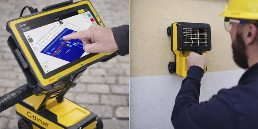
Concrete Slab Scanning
High‑resolution scan of existing slabs, walls, and bridge decks to map rebar spacing, post‑tension cables, and voids. We use a 2.6 GHz antenna for sub‑centimeter resolution. Commonly requested for core drilling, saw‑cutting, and structural modifications.
03
Void & Buried Structure Detection
Targeted survey for underground storage tanks, abandoned septic systems, old foundations, and soil voids. We deploy both 400 MHz and 900 MHz antennas to cover depth ranges from 0.5 m to 4 m. Results are overlaid on current site plans for immediate decision‑making.
Applicable standards
ASCE 38-22 (Standard Guideline for Investigating and Documenting Existing Utilities), IBC 2021 Chapter 18 (Soils and Foundations), OSHA 29 CFR 1926.651 (Excavation requirements for utility location)
Frequently asked questions
How does GPR perform in the clay soils typical of Fremont?
Clay attenuates radar signals, reducing effective depth compared to sandy soils. In Fremont’s silty clay, we typically achieve 2–2.5 m with a 400 MHz antenna. We compensate by using higher gain settings and applying 3D migration filters during post‑processing. For targets deeper than 3 m, we recommend combining GPR with a direct push resistivity survey.
What is the typical turnaround time for a GPR survey report in Fremont?
For standard utility mapping up to 10,000 sq ft, we deliver a georeferenced grid and written report within 48 hours after field work. Larger sites or those requiring 3D volume rendering may take 3–5 business days. Rush service is available for an additional fee.
Can GPR distinguish between a plastic pipe and a concrete pipe?
Yes, but the contrast depends on the dielectric difference. Plastic (PVC) pipes produce a weaker reflection than concrete or metal, so we rely on the shape of the hyperbola and the signal amplitude. We also cross‑reference with any available as‑built records. When ambiguity persists, we flag the target for a test pit excavation.
How much does a GPR survey cost for a typical Fremont residential lot?
For a standard 5,000 sq ft lot with utility mapping and concrete slab scanning, the cost ranges between US$1,070 and US$2,500 depending on the number of target types and site accessibility. We provide a firm fixed price after a quick site walk‑through.